


SKU: PR065
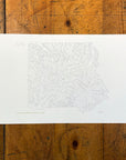
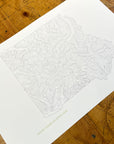
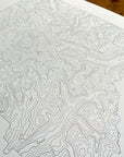
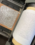
Mount Rainier National Park Topographic Map Letterpress Print
$ 50.00
Topographic map print of Mount Rainier National Park in Washington State hand pressed on an antique letterpress machine.
Mount Rainier was established as the United States' fourth national park in 1899. It consists of Mount Rainier itself and acres of beautiful valleys, waterfalls, and forests that surround the 14,410 ft stratovolcano. As the highest point in the Cascade Range, Mount Rainier is often shrouded in clouds and gets a decent quantity of snow in the winter.
Perfect wall art for map lovers, fans of the outdoors, and National Park enthusiasts. A great way to remember home or a vacation in Washington.